Terrain elevations in the development plan are incorrect.

  • Erstellt am 2012-11-19 23:33:52

Bauexperte

2012-11-21 12:16:15
  • #1
Hello Dietmar,


Very unusual – I don't want to believe that; you are surely talking about a cadastral extract with the mentioned values? Very rarely do I come across such a cadastral extract with height information. A development plan means a development plan; it usually only shows the rough division of the parcels as well as initial details about the development: roof pitch, eaves and ridge heights. The rest can be found in the textual determinations belonging to the development plan.


THAT cannot be; you as well as any other builder need a preliminary site plan to prepare the building application. You are surely confusing something here...

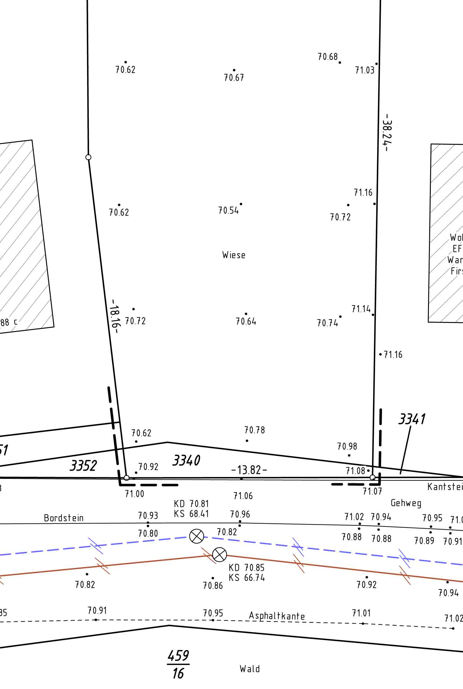
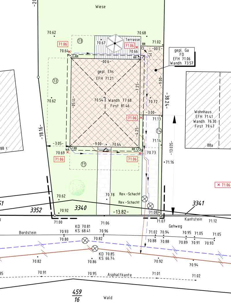
I have attached the first 2 surveyor steps from one of our construction projects. The first preliminary draft shows the terrain heights, the colored preliminary draft the planned house. Only when the house is drawn in is the preliminary draft complete and can be submitted to the building authority for approval along with the building application.


Then I would really like to know what the building authority said about that?


Again – there are no reliable height details on a development plan, and if any, only very rough ones. Development plans are often created years before the release of the ground for construction. This means – conversely – that if height information is recorded, it does not necessarily correspond to reality. That is why, among other things, a publicly appointed surveyor must be involved. Based on his current data, it is determined at what height the house is to be built, how many entrance steps are required, how much money must be spent on removing excess soil/fill, etc.

Who is accompanying you on your construction project, advising you?

Kind regards


hindi63

2012-11-22 00:09:22
  • #2
Hello construction expert,

I would like to send you my site plan and my development plan (I do not want to post them publicly here due to copyright), how can I do that? Apparently, nothing can be attached in PM or email...

Regarding your questions:

The term cadastre only came up with us when the architect needed the sewer connections; she obtained those herself from the office. I personally only saw the surveyor three days before our excavator arrived, that is, 7 months after our building application. Before that, I saw no indication that he had ever been on our property (no paint, no stakes).

We never saw a preliminary site plan either. The only site plan we ever saw was in our file with the building application. By the way, I find your site plan brilliant: enough elevation points to realistically represent the terrain. That’s what I had imagined as well, but we relied on the general contractor and his architect.

Regarding the missing elevations in the building application/site plan, I didn’t ask the building authority. Anyway, no one said anything.

Regarding the reliable elevation data: our general contractor said after the excavation “at least 100m³ more came out. You gave me wrong data.” He said he had never experienced anything like that. We only had the development plan supplied. And 5 months ago (that is, during our building application) we also submitted a geological report on the advice of our building consultant from the Building Owners’ Association (where finally the terrain elevations of our four house corners were included, but despite my notification, neither the general contractor nor his architect asked about it).

That’s it for your questions. And after seeing your site plan, it occurs to me that some of our neighbors (not all) had many stakes in the terrain long before their construction.

Regards, Dietmar
 

hindi63

2012-11-22 23:33:26
  • #3
Today we launched a trial balloon: we went to the mayor’s office hours to complain about our plight.

Our main argument: the street slopes down from east to west along our property by over a meter. At the two eastern neighboring houses, the terrain is almost level with the street. Near the western water reservoir, the terrain is even higher / built up. We suspect that our terrain in between was filled in with the excavation from the water reservoir back then. Apart from the suspicion that we might now have to dispose of the excavation from the municipal utilities, it also looks bad if we are supposed to basically dig a wedge into the terrain.

The mayor now wants to talk to his building department. Let’s wait and see ...
 

hindi63

2012-11-22 23:55:47
  • #4
Oh yes: even the mayor was surprised that the general contractor and the architect probably relied on the development plan and the cadastral map. But we don’t want to start any quarrels with them now either, otherwise we will probably have to forget about our house for the time being...
 

Bauexperte

2012-11-23 12:00:00
  • #5
Hello,


First of all, thank you for the documents!

I stick to my statement: it is definitely a planning error and in any case irresponsible to rely on "one" value in a development plan. However, I still don’t understand how the building authority could approve with these deficient documents; collusion? With us – and I maintain very good contact with all “my” building authorities, even in politics – I wouldn’t get such a BA approved...

In the end, this does not help you either, since you purchased the property and therefore bear responsibility. The accusation you can make against your provider/architect is solely that, based on their statements/plans, you calculated the wrong costs for the earthworks. There are indeed additional foundation costs; you should negotiate this with them regarding a further exemption, should your mayor be able to enforce an adjustment to the neighboring plots.

The municipality will pay no attention to this because they will rightly point out that you are the owner; the different terrain levels should have been visible to you as a layperson before purchase. And any possible “help” from the mayor is based on the fact that even more additional foundation costs will come your way!

AND – don’t back down in further discussions with your provider/architect! You are building “partners” and partners meet each other at eye level!

Kind regards
 

hindi63

2012-12-10 02:22:55
  • #6
Brief interim status: after an on-site meeting with the building authority and the architect of our general contractor, we were able to gain another 30cm (the building authority will probably charge for that again). But:

Now we have conflicting statements: the building authority says a site must be surveyed before the final planning. The architect says if there are heights specified in the development plan, then those must be correct. Well, which statement is correct (in BaWü)?
 

Similar topics
02.09.2013Survey plan: What is its content and where can I get it from10
29.10.2013Property reserved, construction financing plan, architect/building permit application21
27.02.2017Determination of land value of property with existing old structure25
03.05.2017Is terrain modeling allowed on the property?20
05.10.2017Property / Development Plan / Retaining Walls / Excavations17
28.02.2018Deviation from the development plan in the new construction area is possible118
15.08.2018Basic floor area ratio / floor area ratio for plots without a development plan: How to calculate? Experiences?18
02.01.2019Opinion on this property desired!15
26.02.2019Submit a building application before the land is paid for?11
30.07.2019Non-compliance with the development plan by the neighbor101
30.09.2019200m2 single-family house for 4-5 people without a basement on a narrow plot67
22.11.2023Location of city villa or single-family house on 500 m2 plot - rectangular586
14.04.2020How to obtain an exemption from the development plan?53
11.05.2021Neighbor is building a retaining wall on my property. What should I do?87
30.11.2020Building Authority Problems - Purchased a Defective Plot56
30.01.2021The building authority rejects the building application because the house is planned too far back86
30.01.2022Plot 4500 m² (nursery) - preparation of development plan independently16
05.10.2023Single-family house ~200 sqm with double garage on a trapezoidal plot70
29.06.2023Position of garage on property, specification in development plan22
03.08.2024Nice plot of land, but is the development plan too restrictive?21

Oben