LustigerPiet
2019-10-11 11:31:32
- #1
Hello everyone,
I am new here and of course I have properly used the forum search, but unfortunately found nothing suitable for my question.
We are planning to buy a plot of land for a future construction project. However, I noticed something very strange in the development plan (from the 70s or 80s).
The plot is outlined in green. Line 1 is the building boundary according to the plan, Line 2 is the street boundary line. So far so good.
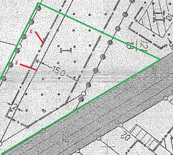
Only: The street is at the bottom of the image, neighboring plots border directly at the top area. Why is there a street boundary line there? And much more importantly: Does this 2-meter-wide strip mean that although the building area is 15 meters wide, in fact only 13 meters may be built on? I have never come across a development plan where the street boundary line runs within the building boundary.
Does anyone have experience with this that they could share with me?
Many thanks in advance!
Best regards
Torben
I am new here and of course I have properly used the forum search, but unfortunately found nothing suitable for my question.
We are planning to buy a plot of land for a future construction project. However, I noticed something very strange in the development plan (from the 70s or 80s).
The plot is outlined in green. Line 1 is the building boundary according to the plan, Line 2 is the street boundary line. So far so good.
Only: The street is at the bottom of the image, neighboring plots border directly at the top area. Why is there a street boundary line there? And much more importantly: Does this 2-meter-wide strip mean that although the building area is 15 meters wide, in fact only 13 meters may be built on? I have never come across a development plan where the street boundary line runs within the building boundary.
Does anyone have experience with this that they could share with me?
Many thanks in advance!
Best regards
Torben