Road edge in the middle of the property

  • Erstellt am 2020-06-10 13:19:31

Isokrates

2020-06-10 13:19:31
  • #1
Good day everyone,

I have a quick question for the construction law experts among us who can surely assess and justify the following situation, as the entire building permit currently depends on it.

I have the following (corner) plot:


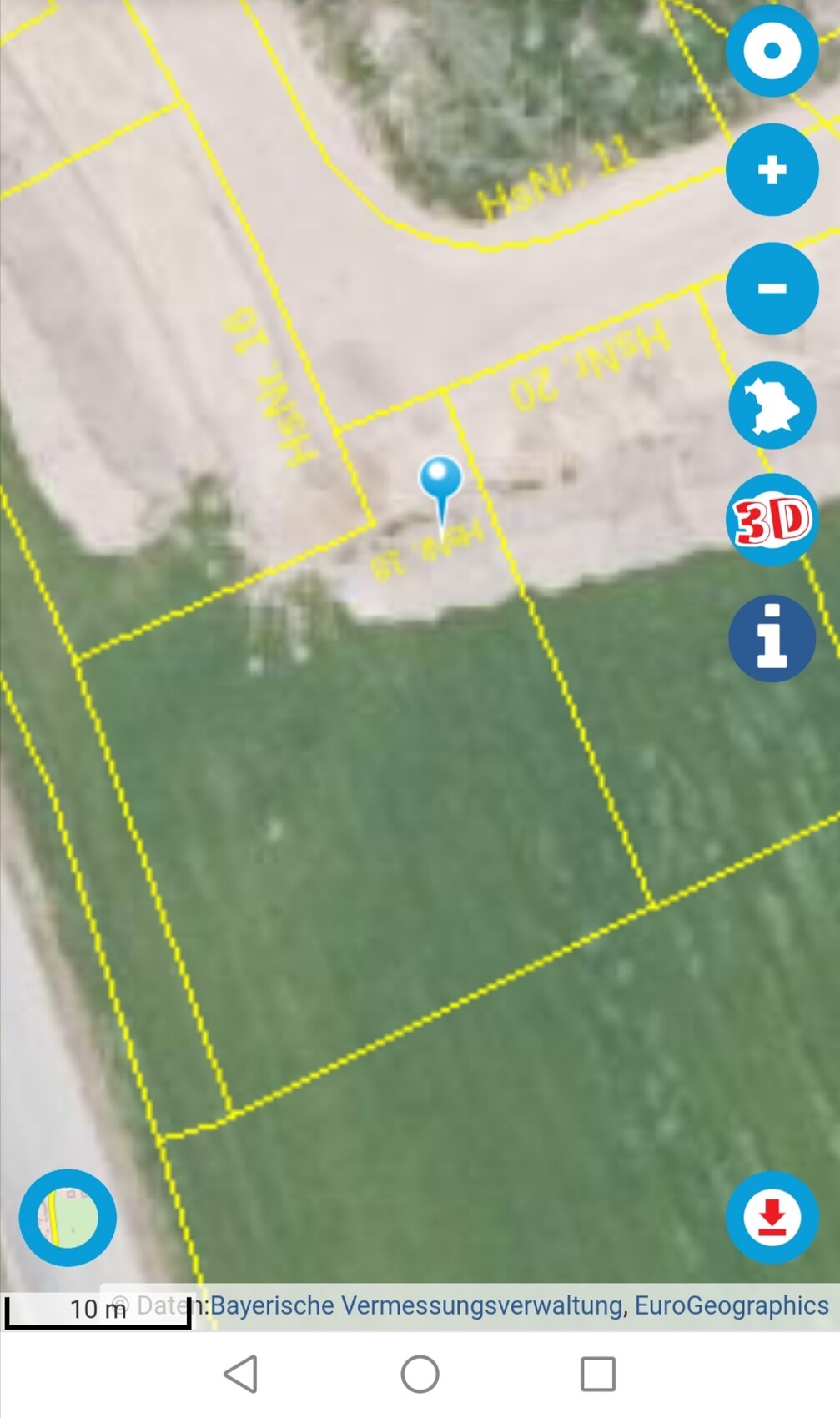
And the following statute regarding the development plan concerning the definition of the baseline for the building height (paragraph 4):


Problem:
After consulting with the architect, there is no street edge in the center of the plot for this property, as only the access part is aligned to the street.
Unfortunately, the building authority does not want to comment on which reference point should now be used.

This problem does not arise for the other plots in the development area, as they all have a full plot width facing the street.
I would be very grateful if someone knew where exactly the reference point must be seen and, if applicable, from which (building) regulation this conclusion can be derived.
I especially hope that could briefly draw from his experience here.

Many thanks in advance for taking the time to review and for any well-founded feedback.
 

Escroda

2020-06-11 10:20:37
  • #2

IMHO clear violation of the definiteness requirement. Very similar case in NRW:
Oberverwaltungsgericht NRW, 10 D 72/09.NE
Lots of text, the most interesting part starts at margin number 57
Similar judgments were issued here:
OVG Nordrhein-Westfalen, judgment of 06.11.2013 - 7 D 16/12.NE
OVG Nordrhein-Westfalen, judgment of 13.02.2014 - 7 D 102/12.NE

Of course, this is of little use to you here and now, since you don’t want to challenge the development plan – or what specific problem is behind
?

Who has expressed what, how, on which question, and by whom? For example, did you go to the building permit authority and ask the caseworker responsible for your building permit at which height above NHN your RFOK ground floor must be, to which they replied, “I do not want to comment on that”?

From the judgments, you can see that it is not an isolated case when city planners want to keep the elevation of the traffic areas open since the technically best realization of the development facilities is hardly foreseeable at the time of the development planning, but on the other hand want to limit the height development of the future buildings. Leaving the legal side aside, a practical solution would be that the civil engineering office (or whoever is responsible for the development planning with you) indicates the expected height above NHN of the red point.
 

Isokrates

2020-06-11 13:16:26
  • #3


Thank you very much in advance for this.


I have submitted a building application with a request for exemption from the height requirement, as the plot is significantly higher than the street in the initial situation (approximately 1.20 - 1.30 m above street level in the actual center of the plot). This deviation is now categorically rejected by the building authority.

The plan is a flat-roofed building with a wall height of 6.11 m from RFOK EG to the parapet (according to the development plan, the height is measured accordingly here). The maximum permitted wall height for a flat-roofed building is 6.50 m, measured from the RFOK EG, which in turn may be at most 0.50 m above the street surface in the center of the plot.

Attached is the submission plan with the indicated heights for better illustration:

[ATTACH alt="Eingabeplan Höhen.png" type="full"]47960[/ATTACH]


Actually, the present matter was already clarified by phone at the beginning of April, because the building authority says the plot requires a deviation regarding the height position, which should be approved since they themselves are not happy with the development plan with regard to the given topography. However, since a new mayor has been in office since early May, it has apparently become a problem, as he definitely does not want to approve any deviation in this newly designated building area.

These insights result from communication via e-mail and telephone with the building authority.

What really makes the whole thing difficult now is the following passage in the development plan:
[ATTACH alt="Geländeveränderungen.png" type="full"]47961[/ATTACH]
With a maximum excavation of 0.50 m, I can never reach the required height of the RFOK EG with a maximum of 0.50 m above the street surface in the center of the plot for the present plot.

Since the building authority now neither wants to approve the present planning with retention of the original terrain heights nor a deviation in the form of an extended excavation (which in my opinion would be absolute nonsense), the key point is the baseline value of the street surface in the center of the plot.
 

Escroda

2020-06-11 13:51:18
  • #4

And is he a lawyer or a building expert?
Is the municipality also the approval authority?

The street height will hardly vary by the required 80cm. Therefore, I don’t see how a height indication should help you.

As I said, height specifications that are not determined or clearly determinable in the development plan itself are invalid and may lead to the ineffectiveness of the entire development plan. If no responsible person wants to take responsibility and is unwilling to negotiate, your only option is legal action.

Posting puzzle pieces is not really my thing anyway – but so many details play a role here that the overall context can probably only be grasped by experts on site. Since your architect owes you an approvable plan, it is primarily his problem to resolve the apparent dilemma. With his experience and professional expertise, he can communicate much better with the people at the authority and therefore give a more reliable advice regarding the sensibility of taking legal action and recommend involving a specialist lawyer.
 

Isokrates

2020-06-11 14:24:41
  • #5


No, he previously worked as a business economist at the Sparkasse.


Fortunately, not really. That is the district office as the building supervision authority.
But as is often the case politically, the district office in Bavaria usually aligns itself with the municipality to avoid straining relations and does not replace the municipal consent.


If the reference point were assumed in the extended driveway, there would only be a height difference of about 1 m, which could be reduced to the required value within the development plan by maximum excavation if you want to avoid the legal route.


Yes, unfortunately, that’s what I fear as well. It’s just annoying because of the time such a procedure takes.


Please excuse the puzzle pieces; I did not want to start with a considerably long initial post and was also not sure what exactly was essential for an answer. Furthermore, you always have to weigh what you want to post on the internet.

Nevertheless, I thank you very much for your comments on my problem.
 

Snowy36

2020-06-11 20:28:03
  • #6
Go to the new mayor and explain the situation to him ... it helped us ... it can't hurt ...
 

Similar topics
15.02.2011Building permit application12
10.12.2012Terrain elevations in the development plan are incorrect.12
04.05.2015How long is a development plan valid?20
11.04.2017Building authority wants site inspection116
04.07.2017Problems with the building authority due to soil slips and retaining walls!27
22.01.2018Building on still foreign land - Waiting for building permit25
21.06.2018What must be included in the building permit? Legal certainty?19
15.08.2018Basic floor area ratio / floor area ratio for plots without a development plan: How to calculate? Experiences?18
26.01.2019Building permit from 1931 not adhered to35
30.01.2019Deviations from the development plan clinker - experiences?27
28.02.2023Evaluation of Savings Bank Interest Offer17

Oben